Elevit and Çatköy, the new favorites of nature tourism lovers, are located in Turkey. As they are only eight kilometers apart from each other, they are often visited by tourists on the same day.
Fırtına Valley and Çatköy
Çatköy is a village located in the Eastern Black Sea Region of Turkey, at the end of the Fırtına Valley. It is 92 km (57 miles) from the provincial center of Rize and 26 km (16 miles) from the district center of Çamlıhemşin. Those coming from Trabzon and Rize should turn to the road to Çamlıhemşin before reaching the Ardeşen district center and follow the Fırtına Valley. Those arriving from Artvin and Georgia can also follow the Fırtına Valley to reach Çatköy and Elevit.
If you don’t take a break after entering the valley, you can reach Çatköy after about 70-90 minutes depending on your speed. However, since you will want to photograph the magnificent beauties you will encounter along the way, this time will probably be a little longer.
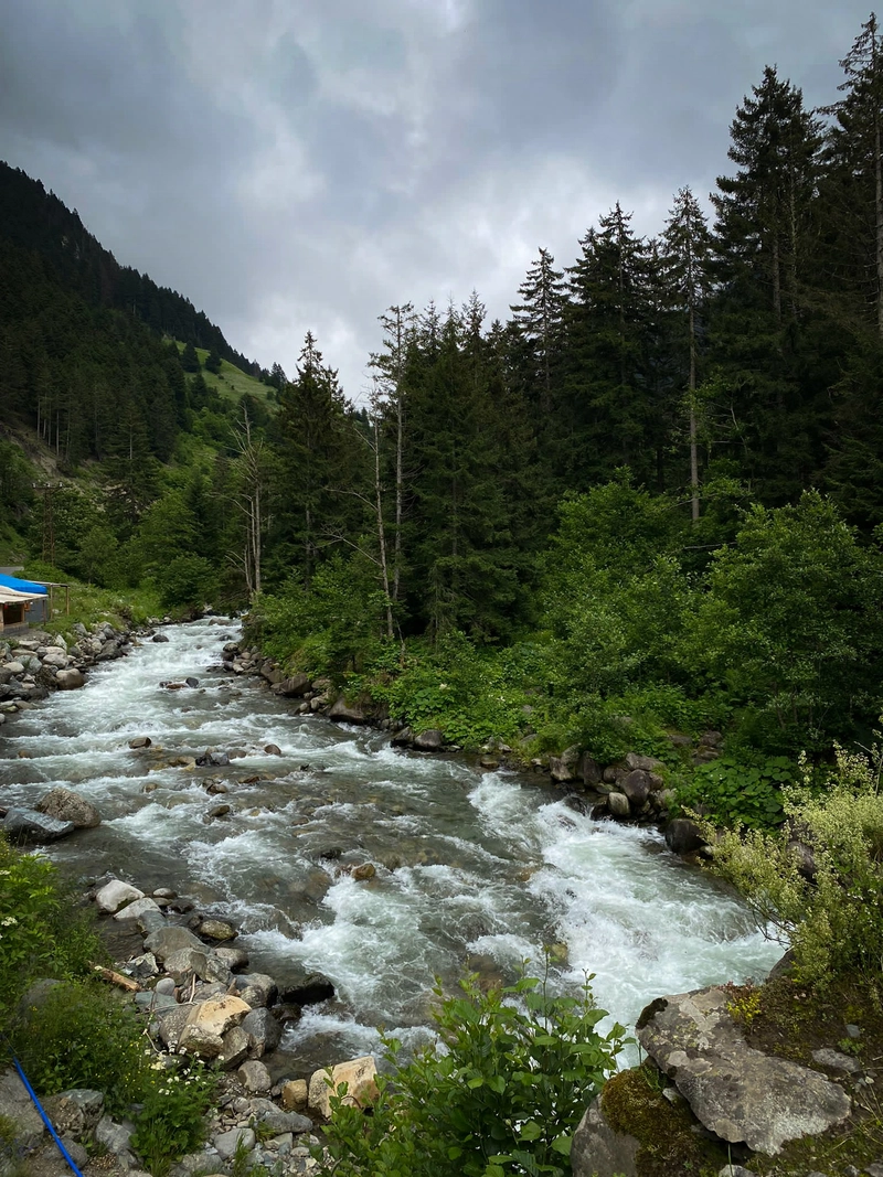
Fırtına Valley is a very good route for both nature lovers and extreme sports enthusiasts. Fırtına River is the first choice of rafting lovers in the region. You will already see many facilities along the way.
A few minutes after arriving at the district center of Çamlıhemşin, the road will split into two. At this stage, you need to continue on the road on your right (west), that is, in the direction of Zilkale (a medieval castle). The road on the left leads directly to Ayder. If it is before the afternoon, you can also visit Zilkale.
After this turn, you will see that the trees become denser. They are the famous boxwood forests of Fırtına Valley, which the WWF has stated should be protected. Unfortunately, they are at risk of drying out due to a fungal disease they contracted in 2010. For this reason, biological control has been practiced in the region for a long time.
As you move through the forests, you will reach Meydanköy first. You will see chalets, authentic hostels and bungalows on the way. Shortly after that, you will reach Çatköy. However, Çatköy is actually 300 meters above the road. The roadside section is more commonly known as Çat Düzü.
If you haven’t had a snack on the way, Çat Düzü is an ideal place for a picnic over daisies and yellow buttercups.
Elevit Yayla
After spending some time in Çat Düzü, it’s time to go to Elevit. The road will split in two again, but this time you will go on the left. The road on the right leads to Kaleköy.

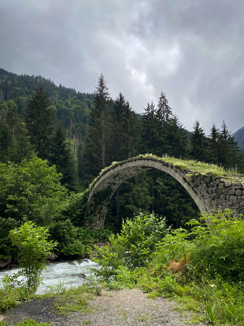
The distance between Çat Düzü and Elevit is approximately eight kilometers. Depending on the road conditions and your speed, you can get there in 40-60 minutes. Although the road is gravel, you can go to Elevit with all types of cars. You can take a break next to the arch bridges on the way and take beautiful photos.
History of Elevit
Before the history of Elevit, it is necessary to briefly talk about what the yayla is. Yayla is the name given to summer highland settlements in Turkish. People dealing with animal husbandry go to the highlands in summer to graze animals. They live there for three or four months in roughly built houses and return in the autumn. In recent years, these settlements have become one of the popular places for nature tourism lovers and those who are tired of the summer heat.
According to Nişanyan Dictionary, the word “Elevit” derives from the Armenian word “Elihovid”, which means high plateau.1
Ethnographer, priest and writer Per Minas Bijishkyan, who lived in the Ottoman Empire in the 19th century, defined Elevit as an Armenian settlement in his book “History and Geography of the Black Sea Coast” written between 1817 and 1819. It is known that Hemshin people lived in the yayla during the Republican period.
Green Paradise in the Fog
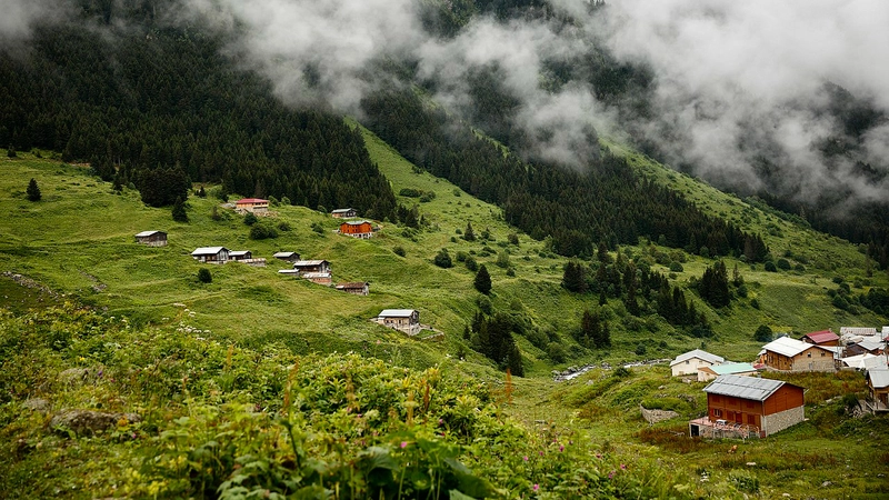
Elevit is now officially known as Yaylaköy, but local people use the name Elevit in daily life.
Elevit, at an altitude of about 1900 meters (6333 ft) is located at the intersection of three valleys. It is surrounded by the Kızılkaya, Güncan and Vaçakar peaks, which are over 3000 meters (9850 ft) high.

The number of houses in Elevit is just over a hundred. The houses were built with wood and stone materials. There is a small grocery store in the yayla, but it is not clear when it is open and when it is closed.
Although the yayla has a peaceful atmosphere and a favorable nature for campers, camping is not allowed in the yayla center. Because animals can cause problems while grazing. For this reason, it is recommended that those who want to camp go a little far from the center of the yayla.
The best time to go to Elevit is from late April to early October. From November to April, the yayla is usually covered with snow.
Transport
You need to go to Rize to visit Çatköy and Elevit, but there are no international flights to Rize. Therefore, you can arrive at Trabzon Airport and go to Rize by bus. It takes about an hour between Rize’s city center and Trabzon.
If you can’t find a flight to Trabzon Airport, we recommend you to check flights via Istanbul or Ankara. There are also direct flights from Istanbul and Ankara to Rize.
- “Nişanyan Sözlük: Çağdaş Türkçenin Etimolojisi”, Sevan NİŞANYAN, Liberus, ISBN: 9786050699937, Website[↩]